The Journey to Sustainability: how satellite imagery can support forest resource governance in the DRC
7th May 2021
Orbital satellite imagery has changed the way humans view the world.
Before 1959, images of the earth were taken by sporadic suborbital space flights, sent out almost a decade apart. What orbital satellites did was replace these photos — taken approximately 1.5 seconds apart, with a seamless capture of every single moment across the globe.
The result of this became the ability to observe even the tiniest of changes, through space and time
Today, it is possible to explore some of the world’s most intricate landscapes from the comfort of our homes. Today, it’s possible to take a trip through time to see if the deep, dark forests of the Congo basin stood the test of human interference, using satellite images.
For nearly three decades, political unrest, border scuffles and armed tribal conflicts facilitated overexploitation and illegal logging in forested landscapes across the Democratic Republic of Congo. The long-drawn-out conflicts, coupled with competing land uses like agriculture and mineral extraction, claimed the lives of forest custodians and wildlife. This civil unrest simply negated any attempts made towards sustainable resource management.
Before DRC’s political transition in 2001, forest governance became ordered by the DRC Forest Code, established under Law No 16–2000. This instrument, which became the key piece of forest legislation in the Republic of Congo, stipulates rights, obligations and management structures for all of DRC’s forested lands, which cover up to 60% of the total land area.
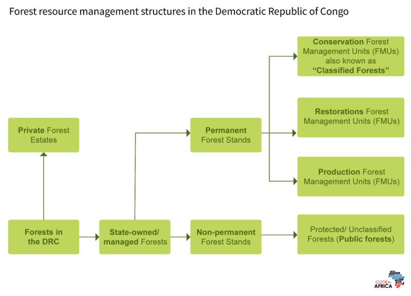
Forest Management in the DRC
Recent legal frameworks, such as the DRC Ministerial Decree №025, also recognize forest-dependent communities’ rights and allow locals to manage up to 50,000 hectares of forested lands autonomously.
Despite what appears to be a well-thought-out management structure, primary forests in the DRC still face several threats, recording up to 4.6% loss over the past two decades alone.
Many patrons of forestry claim that forest resources are better conserved in the hands of the local, where the rate of deforestation has been recorded to be up to 23% lower than the average forest loss countrywide.
Between 2001 and 2019 alone, less than 0.1% of the total tree cover loss was recorded in indigenous and community lands compared to the 2.8% reported in protected areas. The difference in primary forest cover loss under state and community management is significant when reviewed using data such as the one below.
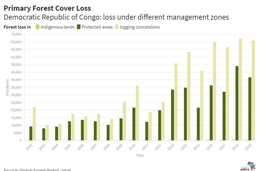
Primary Forest Cover loss in the DRC. Source: Global Forest Watch, 2019.
However, this difference may be attributed to the vast difference in the expanse of forests allocated to communities and that which remains under state management.
Forestry agencies, such as the Centre for International Forest Research (CIFOR), have studied forest user rights and recommend that “revisions of the Forest Code should better reflect the customary tenure system and the role of customary authorities” because of the presumed benefits associated with ‘people managed’ forests. Similarly, nonprofits like the World Resources Institute and the Rainforest Foundation UK advocate for developing a national community forestry strategy.
But do different management structures register varying degrees of success, in terms of forest protection?
What are some of the underlying causes of forest cover loss in areas where degradation has been consistently recorded? Is management style a commonality in these areas? Can community forestry better advance sustainable resource management, in comparison to state custodianship?
Satellite data on forest cover, such as that produced by Global Forest Watch, can be utilized to answer some of these questions and guide in decision-making for forest governance.
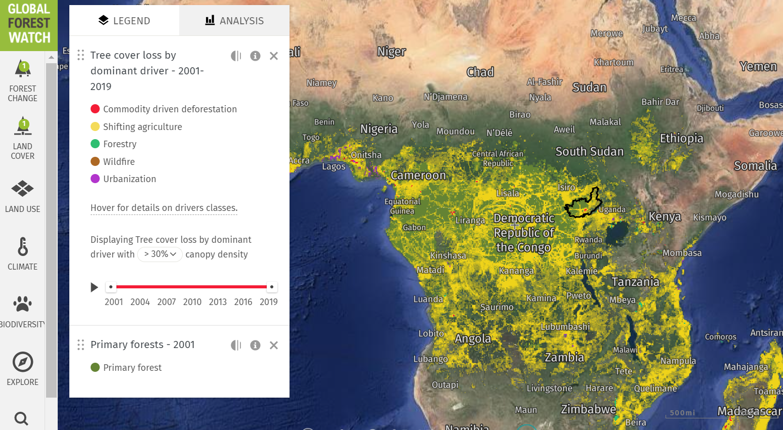
This forest atlas of DRC shows the progression in tree cover loss between 2009 and 2019, highlighting provinces where the highest rate of deforestation was recorded.
In the slider above, evidence of forest cover loss is especially pronounced on the edges of both nature reserves and community forests - making it difficult to commit to the efficiency of community forest management over state management.
Likewise, studying land cover dynamics, province by province, shows little evidence of management efficiency resulting from governance styles.
Substantial answers on the influences of forest cover loss may lie in studying the relationship between forest loss and drivers such as socio-economic activities and population density.
From satellite images like the one below, it is possible to see the influence of socio-economic activities like shifting agriculture on forest coverage.
The claim that ‘forest resource oversight by communities results in better protection than management by the state’ remains a bone of contention requiring further investigation.
What is true is, from satellite imagery, is that forest loss is largely influenced by socio-economic variables such as livelihood options and the complex interaction of these variables with nature.
This story was originally published here by Linda Amanya.
The story was supported by Code for Africa, and funded by the Global Forest Watch (GFW) with support from the Norwegian Ministry of Climate and Environment (KLD). GFW supports data-driven journalism through its Small Grants Fund Initiative. The publisher maintains complete editorial independence over the stories reported using this data.